
By David Khumbanyiwa, WCRP Intern (Geneva, Switzerland)
As climate impacts intensify around the world, especially in the Global South, the integration of artificial intelligence (AI) into climate and agricultural services is opening new opportunities for resilience. From my home country of Malawi to the global climate research community in Geneva, I have seen how data-driven innovations are transforming the ways societies anticipate, adapt to, and recover from climate shocks.
AI Innovations Strengthening Malawi’s Climate Resilience
Malawi, a predominantly agrarian nation, remains highly vulnerable to droughts, floods, and tropical cyclones. In recent years, several AI- and data-based initiatives have emerged to enhance the country’s response to these challenges.
Ulangizi, an AI-driven agricultural advisory platform, provides localized crop management recommendations to smallholder farmers via mobile technology. By integrating meteorological, soil, and satellite data, Ulangizi offers practical advice on crop diversification, pest management, and planting schedules helping farmers adapt to shifting rainfall patterns and improve yields. The system supports English and Chichewa communication, and is accessible through WhatsApp, increasing inclusivity for rural users.

Figure 1. A Malawian farmer consults UlangiziAI, a WhatsApp-based chatbot launched in February, for real-time agricultural advice. (Photo: Elias Wolfberg, Sept 27, 2024)
The Malawi Digital Plant Health Service (MaDiPHS), a project led by the Norwegian Institute of Bioeconomy Research (NIBIO) and funded by NORAD, uses remote sensing and AI-based image recognition—together with local partners like the Ministry of Agriculture and PlantVillage—to detect crop pests and diseases. It supports extension officers and farmers with early warning alerts and management advice, helping to reduce losses from outbreaks linked to climate variability. It empowers extension officers and farmers with early warnings and management advice, helping reduce agricultural losses linked to climate-sensitive pest outbreaks.
Meanwhile, the M-CLIMES initiative, implemented by the Department of Climate Change and Meteorological Services (DCCMS) with support from the UNDP and the Green Climate Fund, is modernizing Malawi’s climate and early warning infrastructure. The project has expanded automatic weather station networks, improved hydrological monitoring, and strengthened information-sharing systems across sectors. 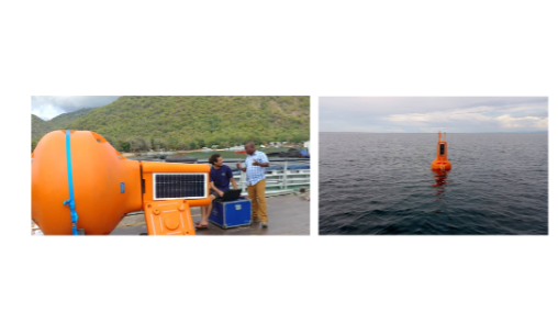
Figure 2. Lake-based weather buoys installed under the M-CLIMES Project on Lake Malawi. (Photo: UNDP, March 2020)
AI in Post-Disaster Assessment: Lessons from Cyclone Freddy
Cyclone Freddy, one of the longest-lasting tropical storms on record, caused extensive flooding and landslides in southern Malawi in March 2023. In its aftermath, AI and geospatial technologies were used to support damage assessment and recovery planning.
The Scotland–Malawi Partnership collaborated with local institutions to analyze Sentinel-1 and Sentinel-2 satellite imagery using vegetation index algorithms (NDVI) to detect flood and landslide damage. These analyses helped identify the most affected districts such as Mulanje, Phalombe, and Chiradzulu—and supported situational awareness for responders.
Researchers from the Malawi University of Business and Applied Sciences (MUBAS) developed the mwBTFreddy dataset, pairing pre- and post-disaster satellite images with annotated building damage levels. This open dataset enables the training of AI models for automated building damage classification and contributes to the development of rapid-assessment tools for future events.
In parallel, humanitarian mapping initiatives led by the Humanitarian OpenStreetMap Team (HOT), Missing Maps, and the Malawi Red Cross Society mobilized volunteers worldwide to map flood-affected areas in southern Malawi. Using satellite and drone imagery, these teams updated road networks, settlements, and health facility data on OpenStreetMap, improving the accuracy of situational maps used by organizations such as UN OCHA, MapAction, and UNDP Malawi for response coordination.
These examples illustrate the growing potential of AI, remote sensing, and crowdsourced geospatial data to complement traditional methods in climate-related disaster management—enabling faster, evidence-based decisions that improve recovery outcomes.
Connecting Local Innovation to Global Climate Research
At the World Climate Research Programme (WCRP) and World Meteorological Organization (WMO), there is growing interest in the use of AI for climate prediction, data assimilation, and Earth system modelling. The principles demonstrated in Malawi in terms of data accessibility, local participation, and cross-sector collaboration align with global efforts to make climate information more actionable and inclusive.
Malawi’s experience shows that success in applying AI for climate resilience depends on local relevance, ethical data use, and sustained capacity building. Insights from WCRP’s initiatives on machine learning for climate science can, in turn, help strengthen similar data-driven approaches in regions with limited observational capacity.
A Call for Inclusive Digital Climate Resilience
AI is not a silver bullet. Its effectiveness depends on reliable data, human expertise, and equitable access to digital tools. Yet Malawi’s progress demonstrates that when local innovators, national institutions, and international frameworks such as WMO and WCRP collaborate, AI can make climate services more responsive and inclusive.
As I continue my journey from Malawi to Geneva, I am reminded that climate resilience is built not only through advanced algorithms but also through shared knowledge, open science, and the collective will to adapt.